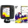
Detail Garmin Fishfinder Echo™ 500c Call Irfan 021-51176451
garmin fishfinder echo™ 500c call irfan 021-51176451 / 081908101888/ 08998723423
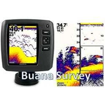
With 500 watts ( RMS) power, depths to 1, 900 ft and a 5 in color display, echo 500c ushers in the next generation of fishfinders.
Experience Picture-Perfect Fishing
When bragging rights are on the line, this is the technology to turn to. echo 500c scans the waters with 500 watts RMS power and extra-sensitive Garmin HD-ID™ target tracking technology. Then it displays what it sees on a 5 in QVGA display. A dual-beam transducer optimizes performance for deep or shallow water, offering wide-angle ( up to 120 degree) coverage to target fish beyond the sides of your boat and the ability to scan bottom profiles down to 1, 900 ft.
For an uninterrupted view of the sonar image, echo 500c boasts Garmin Smooth Scaling™ technology, which means you won’ t lose sight of the sonar history as the unit changes depth ranges. It also features the ability to rewind your sonar history in order to ensure that you haven' t missed a thing.
Mount & Go
echo 500c is one of the most intuitive fishfinders on the market. Installation takes only a few minutes using the quick-release tilt mount and versatile transom-mount transducer included in the box.
echo 500c features:
Garmin HD-ID™ technology
500 watts ( RMS) transmit power
Depths to 1, 900 ft
Beam width to 120 degrees
5 in sunlight-readable QVGA color display
Tilt/ swivel mount, transducer, trolling motor clamp and transom mount
Physical & Performance:
Unit dimensions, WxHxD: 6.0 " x 5.9 " x 1.8 " ( 15.2 x 15.0 x 4.6 cm)
Display size, WxH: 2.9” x 4.0” ( 7.4 x 10.16 cm) ; 5” diag, ( 12.7 cm)
Display resolution, WxH: 234 x 320 pixels
Display type: QVGA, 256 colors
Weight: 17.6 oz ( 499 g)
Waterproof: yes ( IPX7)
Features & Benefits:
Audible alarms: yes
Dual-frequency sonar capable: yes
Dual-beam sonar capable : yes
Split-screen zoom: yes
Ultrascroll® ( displays fish targets at higher boat speeds) : yes
Fish Symbol ID ( helps identify fish targets) : yes
AutoGain Technology ( minimizes clutter, maximizes targets) : yes
Whiteline ( indicates hard or soft bottom) : no
Adjustable depth line ( measures depth of underwater objects) : yes
A-scope ( real time display of fish passing through transducer beam) : yes
Bottom lock ( shows return from the bottom up) : yes
Water temperature log and graph: yes
Water temperature sensor included: yes
Water speed capable ( displays speed on water) : yes
Other:
Frequency: 200/ 77 kHz
Transmit power: 500W ( RMS) / 4, 000W ( peak to peak)
Voltage range: 10V - 28V input
Maximum depth: 1, 900 ft freshwater*
Cone angle: 60º or 120º ( dual beam)
Additional: * Depth capacity is dependent on water bottom type and other water conditions.
What' s in the Box:
echo 500c
Quick release mount with tilt and swivel
Power cable
Transducer w/ mounting bracket, hardware and trolling motor clamp
Documentation
GARMIN GPSMAP® 62s Call Irfan 081908101888 / 085282731888 / 02151176451 / 7321129
OverView:
The newly designed GPSMAP 62s handheld navigator features a 3-axis tilt-compensated compass, a barometric altimeter and supports Custom Maps, BirdsEye™ Satellite imagery ( subscription required) and photo navigation. Rugged and waterproof, GPSMAP 62s employs a quad helix antenna for unparalleled reception, has a high-speed USB connection, a sleek new design and connects wirelessly to compatible Garmin handhelds.
Explore
GPSMAP 62s comes with built-in worldwide basemap with shaded relief, so you can navigate anywhere with ease. With photo navigation, you can download pictures from Garmin Connect™ Photos and navigate to them.
Get Your Bearings
GPSMAP 62s has a built-in 3-axis tilt-compensated electronic compass, which shows your heading even when you’ re standing still, without holding it level. Its barometric altimeter tracks changes in pressure to pinpoint your precise altitude, and you can even use it to plot barometric pressure over time, which can help you keep an eye on changing weather conditions.
Share Wirelessly
With GPSMAP 62s you can share your waypoints, tracks, routes and geocaches wirelessly with other compatible Garmin device users. So now your friends can also enjoy your favorite hike or cache — simply press “ send” to transfer your information to similar units, and let the games begin.
Keep Your Fix
With its quad helix antenna and high-sensitivity, WAAS-enabled GPS receiver and HotFix® satellite prediction, GPSMAP 62s locates your position quickly and precisely and maintains its GPS location even in heavy cover and deep canyons. The advantage is clear — whether you’ re in deep woods or just near tall buildings and trees, you can count on GPSMAP 62s to help you find your way when you need it the most.
BirdsEye™ satellite image
Add Maps
Adding more maps is easy with Garmin' s wide array of detailed topographic, marine and road maps. With 1.7 GB of onboard memory, you can conveniently download 24K and 100K TOPO maps and hit the trail, plug in BlueChart® g2 preloaded cards for a great day on the water or City Navigator NT® map data for turn-by-turn routing on roads ( see maps tab for compatible maps) . GPSMAP 62s also supports BirdsEye™ Satellite Imagery ( subscription required) , that lets you download satellite images to your device and integrate them with your maps. In addition, the 62s is compatible with Custom Maps, free software that transforms paper and electronic maps into downloadable maps for your device.
Get Connected
You' ve been busy exploring and now you want to store and analyze your activities. With a simple connection to your computer and to the Internet, you can get a detailed analysis of your activities and send tracks to your outdoor device using Garmin Connect™ . This one-stop site offers an activity table and allows you to view your activities on a map using Google™ Earth. Explore other routes uploaded by millions of Garmin Connect users and share your experiences on Twitter® and Facebook® . Getting started is easy, so get out there, explore, and share.
Find Fun
GPSMAP 62s supports geocaching GPX files for downloading geocaches and details straight to your unit. By going paperless, you' re not only helping the environment but also improving efficiency. GPSMAP 62s stores and displays key information, including location, terrain, difficulty, hints and descriptions, which means no more manually entering coordinates and paper print outs! Simply upload the GPX file to your unit and start hunting for caches. Slim and lightweight, 62s is the perfect companion for all your outdoor pursuits.
Physical & Performance:
Unit dimensions, WxHxD: 2.4 " x 6.3 " x 1.4 " ( 6.1 x 16.0 x 3.6 cm)
Display size, WxH: 1.43 " x 2.15 " ( 3.6 x 5.5 cm) ; 2.6 " diag ( 6.6 cm)
Display resolution, WxH: 160 x 240 pixels
Display type: transflective, 65-K color TFT
Weight: 9.2 oz ( 260.1 g) with batteries
Battery: 2 AA batteries ( not included) ; NiMH or Lithium recommended
Battery life: 20 hours
Waterproof: yes ( IPX7)
Floats: no
High-sensitivity receiver: yes
Interface: high-speed USB and NMEA 0183 compatible
Maps & Memory:
Basemap: yes
Preloaded maps: no
Ability to add maps: yes
Built-in memory: 1.7 GB
Accepts data cards: microSD™ card ( not included)
Waypoints/ favorites/ locations: 2000
Routes: 200
Track log: 10, 000 points, 200 saved tracks
Features & Benefits:
Automatic routing ( turn by turn routing on roads) : yes ( with optional mapping for detailed roads)
Electronic compass: yes ( tilt-compensated, 3-axis)
Touchscreen: no
Barometric altimeter: yes
Camera: no
Geocaching-friendly: yes ( paperless)
Custom maps compatible: yes
Photo navigation ( navigate to geotagged photos) : yes
Outdoor GPS games: no
Hunt/ fish calendar: yes
Sun and moon information: yes
Tide tables: yes
Area calculation: yes
Custom POIs ( ability to add additional points of interest) : yes
Unit-to-unit transfer ( shares data wirelessly with similar units) : yes
Picture viewer: yes
Garmin Connect™ compatible ( online community where you analyze, categorize and share data) : yes
What' s in the Box:
GPSMAP 62s
Indonesia Map
Micro SD 2GB
Carabiner clip
USB cable
Manuals
Fluke 52 Seri II, 52II, 52ii, Contact Thermometers, Call Irfan 02151176451
Specifications
Temperature accuracy
Above -100 ° C: J, K, T, E, and N-type: ± [ 0.05% + 0.3° C] *
R and S-type: ± [ 0.05% + 0.4° C] *
Below -100 ° C: J, K, E, and N-types: ± [ 0.20% + 0.3° C] *
T-type: ± [ 0.50% + 0.3° C]
Temperature
J-type: -210 ° C to 1200 ° C
K-type: -200 ° C to 1372 ° C
T-type: -250 ° C to 400 ° C
E-type: -150 ° C to 1000 ° C
N-type: -200 ° C to 1300 ° C *
R and S-type: 0 ° C to 1767 ° C *
Temperature scale
ITS-90
Applicable standards
NIST-175
Display Resolution
0.1 ° C, 0.1 K = 1000
Note
* Only the Fluke Models 53 II B and 54 II B thermometers are capable of measuring N, R, and S-type thermocouples.
Environmental Specifications
Operating Temperature
-10 ° C to 50 ° C
Storage Temperature
-40 ° C to 60 ° C
Humidity ( Without Condensation)
0% to 90% ; 0 ° C to 35 ° C
0% to 70% ; 0 ° C to 50 ° C
Safety Specifications
Overvoltage category
CSA C22.2 No. 1010.1 1992; EN 61010 Amendments 1, 2
Agency Approvals
CE, CSA, TÜ V ( pending)
Mechanical & General Specifications
Size
173 mm L x 86 mm W x 38 mm
Weight
400 g
Batteries
3 AA batteries; typical 1000-hour life
Hubungi Buana Survey
Jl. Ciledug Raya Kompelek Taman Surya Buana Blok L 19
Kreo - Cipadu, Ciledug - Tangerang 15155
Cp : Irfan
T : 021-51176451 / 7321129 / 71458381 / 32741737
F : 021-7302811
HP : 081908101888/ 085282731888/ 08998723423
Tampilkan Lebih Banyak